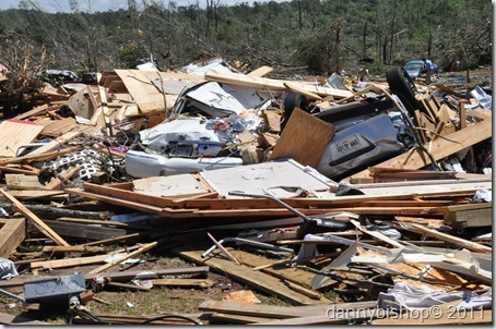
May is usually the most active month of the year for tornadoes, April’s 600 plus tornadoes broke the all time record of 543 set in May of 2003.
The greatest impact of a disaster is not always the destruction of one community, but the lessons learned in dealing with the aftermath. Looking back at the tornado of April 28th, just how prepared were you for a storm that severe?
The average warning time for a tornado today is 24 minutes, that’s plenty of time to activate a plan, but not enough to attempt to come up with one after you hear the warning.
The Warning Sirens:
According to Emergency Management Director, Billy Mitcham, Upson County has 15 sirens placed as close to populated areas around the city of Thomaston and county as possible, they do not cover the entire county, their effective range under ideal conditions is about 1 mile. All of the sirens are activated at the 911 center, at the same time, using radio signals. A siren can be disabled by a lightning strike or a downed power line and not work at all. The county adds additional sirens when funds are available.
The sirens are tested the first Wednesday of each month at 1 pm if the weather is clear.
The purpose of a siren is to warn residents that are outdoors that they need to seek shelter indoors and immediately monitor the weather warnings on TV and radio. They can not be relied on to wake someone up in the middle of the night and they are not meant to be someone’s first indication of dangerous weather in the area.
The sirens are sounded for a period of 3 to 5 minutes as soon as a warning is issued. The sirens will not sound during the entire time the warning is in effect and the severe thunderstorm or tornado may not have reached the county at the time the sirens are activated.
The sirens will only be activated once for each warning.
A second siren means a second warning has been issued.
Spalding County does not have any sirens and Lamar County only has them in the city of Barnesville.
The FCC announced a new program today called the Personal Localized Alerting Network (PLAN-click here for more info) that will allow geographically targeted text messages to cellphones. The deadline to have the program available nationwide is April, 2012.
This program is meant to supplement the existing Emergency Broadcast System and it is still important to have a NOAA Weather Radio to obtain warnings as soon as possible.
As the fast moving supercell thunderstorm, with an EF-3 tornado spinning from the southwest side of it, cut a deadly path from Harris County across middle Georgia to Butts County, there was very little time to prepare for its impact. Any plans for dealing with severe weather should have been made well in advance.
If you don’t have a plan, now is the time to decide how you and your family will react before and after the sirens are sounded again.
Mobile Homes:
The first rule if you live in a mobile home is…. Get Out Ahead Of Time!

Over half of all deaths associated with tornadoes involve a mobile home.
Most tornadoes will not severely damage a sturdily built home, but will damage a mobile home in their path, the odds are 15 to 20 times greater that you will be killed in a mobile home. All four of the fatalities in Spalding and Lamar counties involved mobile homes.
Shelters:
There are no shelters available for residents before a storm strikes, the ultimate responsibility to survive a tornado is up to each individual household, make a plan in advance. Contact a friend or relative in a sturdy home, preferably with a basement and make plans to get there before the warning sirens are activated.
If you plan to use a basement shelter in your home, make sure you have water, food, clothing, medicine, a flashlight and some type of saw or tools that may be needed to remove debris blocking your exit. Having someone in the family trained in basic first aid and CPR could save your life. It may take several hours for emergency personnel to reach your location.
Shelters will be made available following a disaster but local officials must be certain the structure is safe and can be reached safely by those needing it before designating it for shelter use.
Power Outages:
Power outages are going to happen during severe weather and even the most unprepared homes normally have a flashlight available. Test the light on a regular basis and have extra batteries available, candles and propane lanterns are not a good idea since a damaged tank or gas line may cause an explosion.
Have a battery powered NOAA Weather Radio to monitor warnings if your power is lost. The better units can be used to charge your cell phone and have AM/FM radios, S.A.M.E. technology, a clock, a flashlight and are charged by either a crank, solar, battery or AC power, they are priced under $80.00.
If your home has a generator, Upson EMC or Georgia Power needs to know in advance, they can bleed power back onto downed lines and injure or kill anyone coming in contact with them. Avoid downed power lines, do not attempt to drive over them or move them.
Phone Outages:
One of the major disruptions caused by the tornado on April 28th was the loss of phone service by Windstream. The interruption shut down the 911 system in Upson County as well as all long distance calls that are normally routed through either Manchester or Barnesville to the AT&T network. Cell service to land lines was also unavailable.
The tornado first struck a major fiber optic cable in Manchester that connected the companies lines through Woodbury to Griffin, 1800 feet of the cable was totally destroyed. Long distance calls from Thomaston and Upson County that were normally routed through this line, were immediately switched to the second line that ran through Barnesville. That line was destroyed about 30 minutes later, effectively cutting all ties from local phone service to outside areas.
Internet service remained available since it uses a buried fiber optic cable that runs from Thomaston to Macon.
Windstream crews have worked continuously since the storm and have replaced the line in Manchester along with 18 poles and over 33,000 feet of aerial line to customers homes and businesses. The company is now considering the addition of a switch that would add the Macon line as an option to keep essential services available if the other two were to be interrupted again.
Windstream is capable of handling calls at about 80% of capacity under normal conditions, immediately following the storm the system experienced nearly 99% capacity. This causes the overloaded system to either not ring at all or the caller gets a busy signal.
It is essential that residents understand the importance of not making phone calls either by land line or cellular service that are not absolutely necessary.
There is a limit to what the system can handle and exceeding that limit can be life threatening.
The Federal Emergency Management Agency (FEMA) provides an emergency list to help prepare for another tornado and there will be another one.
The idea that Upson County is protected by the hills to the west and north is a myth, the supercell that spawned the April 28th tornado could have easily been six miles to the south and plowed right through Thomaston. A supercell reaching a height of 45 to 50,000 feet is not affected by a small ridge, the supercell that created the Barnesville tornado was small compared to most and the tornado traveled along the top of the ridge north of Thomaston for several miles.
Click Here For FEMA Emergency List
In Your Home Or Business:
■ The safest place to be is an underground shelter, basement, or
safe room.
■ If no underground shelter or safe room is available, a small, windowless
interior room or hallway on the lowest level of a sturdy building is the
safest alternative.
■ Mobile homes are not safe during tornadoes. Abandon mobile homes
and go to a sturdy building.
If you are caught outside:
- If you are caught outdoors and a basement or sturdy building is unavailable:
- Immediately get into a vehicle, buckle your seat belt and try to drive to the closest sturdy shelter.
- If flying debris occurs while you are driving, pull over and park. Now you have the following options as a last resort:
- Stay in your vehicle with the seat belt on. Put your head down below the windows, covering it with your hands and a blanket if possible.
- If you can safely get noticeably lower than the level of the roadway, exit your car, and lie in that area, covering your head with your hands.
Anyone with a disability may have additional needs that will require more time to prepare, click here for information that may help.
Senior citizens also may require more than the items included in the basic list, click here for recommendations.
Pets are an important part of your plan, if you have pets click here for help making preparations.
Stay alert, pay attention to what’s happening west of here since most, but not all, of our weather usually comes from that direction, listen to broadcasts of watches and warnings, program your NOAA Weather Radio to alert you if weather approaches your area. Middle of the night tornadoes are more dangerous, a radio with an alarm may give you just enough time to reach a safe place.
The National Weather Service radar is available to anyone with internet service and will show immediate warnings as well as the path of storms. A number of different views are available and becoming familiar with the site before severe weather strikes is recommended.
Click here to see the national map, click on the regional maps or an area of the national map to see individual radar coverage areas.
Fun 101 broadcast several warnings for the April 28th tornado before the power was lost to our transmission tower. We were off the air until mid-afternoon but we continued to broadcast on the internet and post damage reports to our web site. Your best defense against severe weather is to be informed and have a plan that includes as many ways as possible to obtain that information. Keep you phone calls to emergency only, use your TV, radio and internet.
Be Prepared, You Are Responsible For Your Safety


